


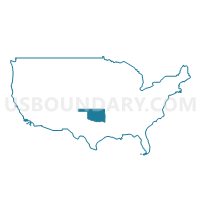
Cherokee, Sequoyah & Adair Counties PUMA, Oklahoma
About
Outline

Summary
| Unique Area Identifier | 193781 |
| Name | Cherokee, Sequoyah & Adair Counties PUMA |
| State | Oklahoma |
| Area (square miles) | 2,067.50 |
| Land Area (square miles) | 1,996.16 |
| Water Area (square miles) | 71.34 |
| % of Land Area | 96.55 |
| % of Water Area | 3.45 |
| Latitude of the Internal Point | 35.75390930 |
| Longtitude of the Internal Point | -94.82119350 |
Maps

Graphs
Select a template below for downloading or customizing gragh for Cherokee, Sequoyah & Adair Counties PUMA, Oklahoma


Neighbors
Neighoring Public Use Microdata Area (by Name) Neighboring Public Use Microdata Area on the Map
- Benton County PUMA, AR
- Muskogee, Okmulgee, Wagoner (East) & McIntosh Counties PUMA, OK
- Northeast Oklahoma PUMA, OK
- Sebastian & Crawford Counties PUMA, AR
- Southeast Oklahoma PUMA, OK
- Washington County PUMA, AR
Top 10 Neighboring County (by Population) Neighboring County on the Map
- Benton County, AR (221,339)
- Washington County, AR (203,065)
- Sebastian County, AR (125,744)
- Wagoner County, OK (73,085)
- Muskogee County, OK (70,990)
- Crawford County, AR (61,948)
- Le Flore County, OK (50,384)
- Cherokee County, OK (46,987)
- Sequoyah County, OK (42,391)
- Delaware County, OK (41,487)
Top 10 Neighboring County Subdivision (by Population) Neighboring County Subdivision on the Map
- Upper township, Sebastian County, AR (76,938)
- Muskogee CCD, Muskogee County, OK (55,694)
- Tahlequah CCD, Cherokee County, OK (22,868)
- Wagoner CCD, Wagoner County, OK (17,111)
- Township 13, Benton County, AR (13,230)
- Muldrow CCD, Sequoyah County, OK (10,626)
- Stilwell East CCD, Adair County, OK (9,641)
- Roland CCD, Sequoyah County, OK (9,632)
- Sallisaw CCD, Sequoyah County, OK (9,198)
- Vian CCD, Sequoyah County, OK (8,077)
Top 10 Neighboring Place (by Population) Neighboring Place on the Map
- Fort Smith city, AR (86,209)
- Tahlequah city, OK (15,753)
- Sallisaw city, OK (8,880)
- Fort Gibson town, OK (4,154)
- Stilwell city, OK (3,949)
- Park Hill CDP, OK (3,909)
- Muldrow town, OK (3,466)
- Roland town, OK (3,169)
- Westville town, OK (1,639)
- Vian town, OK (1,466)
Top 10 Neighboring Elementary School District (by Population) Neighboring Elementary School District on the Map
- Keys Public Schools, OK (4,534)
- Grand View Public School, OK (4,254)
- Briggs Public School, OK (2,668)
- Liberty Public School, OK (2,483)
- Moseley Public School, OK (2,019)
- Peggs Public School, OK (1,662)
- Norwood Public School, OK (1,565)
- Woodall Public School, OK (1,479)
- Tenkiller Public School, OK (1,475)
- Brushy Public School, OK (1,464)
Top 10 Neighboring Unified School District (by Population) Neighboring Unified School District on the Map
- Fort Smith Public Schools, AR (89,450)
- Van Buren School District, AR (33,254)
- Siloam Springs Schools, AR (21,753)
- Tahlequah Public Schools, OK (21,386)
- Wagoner Public Schools, OK (13,751)
- Sallisaw Public Schools, OK (12,287)
- Muldrow Public Schools, OK (8,038)
- Locust Grove Public Schools, OK (7,505)
- Fort Gibson Public Schools, OK (7,254)
- Lincoln School District, AR (7,060)
Top 10 Neighboring State Legislative District Lower Chamber (by Population) Neighboring State Legislative District Lower Chamber on the Map
- State House District 12, OK (40,061)
- State House District 2, OK (37,808)
- State House District 4, OK (37,367)
- State House District 86, OK (36,615)
- State House District 8, OK (36,607)
- State House District 3, OK (35,355)
- State House District 15, OK (35,338)
- State House District 14, OK (34,906)
- State House District 97, AR (34,766)
- State House District 87, AR (30,579)
Top 10 Neighboring State Legislative District Upper Chamber (by Population) Neighboring State Legislative District Upper Chamber on the Map
- State Senate District 9, AR (116,144)
- State Senate District 35, AR (102,238)
- State Senate District 3, AR (87,143)
- State Senate District 13, AR (82,857)
- State Senate District 3, OK (80,333)
- State Senate District 18, OK (78,236)
- State Senate District 4, OK (78,222)
- State Senate District 1, OK (75,819)
- State Senate District 9, OK (75,370)
- State Senate District 7, OK (73,650)
Top 10 Neighboring 111th Congressional District (by Population) Neighboring 111th Congressional District on the Map
- Congressional District 3, AR (822,564)
- Congressional District 1, OK (754,310)
- Congressional District 2, OK (729,887)
Top 10 Neighboring Census Tract (by Population) Neighboring Census Tract on the Map
- Census Tract 202.03, Crawford County, AR (7,605)
- Census Tract 14, Muskogee County, OK (7,207)
- Census Tract 105.04, Washington County, AR (7,102)
- Census Tract 301.04, Sequoyah County, OK (6,992)
- Census Tract 303.02, Sequoyah County, OK (6,931)
- Census Tract 9779, Cherokee County, OK (6,776)
- Census Tract 15, Muskogee County, OK (6,699)
- Census Tract 304.02, Sequoyah County, OK (6,617)
- Census Tract 213.01, Benton County, AR (6,518)
- Census Tract 9777, Cherokee County, OK (6,434)
Top 10 Neighboring 5-Digit ZIP Code Tabulation Area (by Population) Neighboring 5-Digit ZIP Code Tabulation Area on the Map
- 72956, AR (34,074)
- 74464, OK (30,111)
- 72901, AR (21,591)
- 72761, AR (21,211)
- 74955, OK (15,344)
- 74467, OK (14,995)
- 74960, OK (13,643)
- 74948, OK (12,788)
- 74434, OK (9,067)
- 74462, OK (7,875)